Zabaikalsky National Park. Specially protected natural areas
The Trans-Baikal Territory is located mainly in the Amur Basin: the drainage basin formed by the constituents (Shilka and Argun) and Amur tributaries occupies 56% of the region's area. This territory includes, in particular, the central and southern regions of the region, in which about 90% of the population lives. At the same time, the basin has a transboundary character, since it connects the Trans-Baikal Territory with the neighboring provinces of China and Mongolia. The most typical environmental problems for this territory are such as the decrease in forest areas due to fires and felling, the influence of the mining industry and, first of all, gold mining, domestic pollution of watercourses and coastlines, anthropogenic pressure on ichthyocenoses, and so on.
V last years increased or new threats to aquatic and coastal ecosystems in the region have emerged. Catastrophic fires of recent years could not but affect the water-regulating function of forests. Periodically, projects for the construction of dams in the channels of large rivers (Shilka, Nercha, Amazar) appear or are revived. Industrial growth in China has led to increased pollution of Argun and an increase in water consumption for the needs of the mining industry and agriculture in Inner Mongolia.
At the same time, in the Trans-Baikal Territory, the risks associated with cross-border Chinese investments in the forest industry and, in the future, in agriculture are increasing. In particular, in the eastern border regions of the Trans-Baikal Territory (Mogochinsky, Tungiro-Olekminsky, Sretensky, Gazimuro-Zavodsky, Nerchinsko-Zavodskoy), clear felling of forests is assumed on vast territories transferred on a long-term lease, which may be one of the negative factors that have a destructive effect on the state of both terrestrial and aquatic ecosystems in large areas. These threats require both an assessment of the possible consequences and the adoption of necessary preventive measures, including the creation of new specially protected natural areas (SPNA).
Currently, the areas of protected areas within the Trans-Baikal Territory make up 5.3% of the region's territory. Some of them are two reserves (Sokhondinsky and Daursky), national park(Alkhanai), the natural park (Arey) and 13 reserves are fully or partially located in the Amur basin. However, mainly shallow watercourses fell within the boundaries of these PAs. Until recently, the region was practically devoid of protected areas in river beds belonging to the category of large (more than 500 km long) and determining the specifics of the regional part of the Amur basin - Shilka, Argun, Onon, Ingoda, Nerch, Gazimur and the Amur itself. Only an insignificant part of them turned out to be associated with specially protected natural areas. Thus, the sources of the Ingoda are protected within the Sokhondinsky reserve, and a small (about 10 km) part of the Aginskaya steppe regional reserve goes to the left bank of the Onon.
At the same time, in recent years, large reserves of Ergun, Vuma and Beijikun have been created in the border areas of China on the right bank of the Argunia Amur. To date, almost all of the Chinese coastal area in the lower reaches of the Argun for about 300 km along the border with Russia is occupied by specially protected natural areas, which are actively used, in particular, for the development of rural and ecological tourism.
It should also be noted that there are significant differences in the dynamics of forest areas on different banks of the Argun and Amur in recent years, which are manifested in a noticeable fragmentation of forest areas on Russian side... The key reasons for this should be sought, first of all, in the transboundary differences in the organization of forest fire fighting.
This kind of imbalance in approaches to the ways of nature management and nature protection in the short term can lead to the formation of a geopolitically extremely dangerous situation in which the well-being and stability of the Chinese border regions will be ensured through both environmentally friendly forms of economic activity and the export of raw materials from Transbaikalia. This imbalance can cause not only long-term environmental, but also serious reputational consequences, both for the Trans-Baikal Territory and for the country as a whole; The solution to this problem is impossible without searching for comprehensive solutions, but it undoubtedly should include the creation of new protected areas as a reservoir for conservation biodiversity and potential for the development of ecotourism activities, including (and perhaps primarily) with the involvement of Chinese investments and tour operators. In each of these cases, those territories that are geographically linked to the main watercourses may be of particular importance.
In this regard, in recent years in the Trans-Baikal Territory, activity has intensified to create new protected areas, one of the functions of which would be to preserve not only the basins, but also the main channels of large watercourses. As a result of this, justifications were prepared for the creation of a number of regional reserves, first of all, such as "Relict Oaks", Verkhneamursky and Sredneargunsky (Fig. 1).

Rice. 1. Borders of the created and created PAs in the Russian-Chinese border area. 1- nature reserve "Relitovye oaks" (Russia); 2- reserve Yergun (PRC); 3- Wildlife Forest Wuma Wildlife Sanctuary (PRC); 4 - Beijikun nature reserve (PRC); 5- nature reserve "Urushinsky" (Russia); 6 - Ulegir nature reserve (Russia).
At present, only for one of the aforementioned zakazniks - "Relict Oaks" - with the support of the Amur branch of WWF-Russia, a full cycle of organizational activities has been carried out. This made it possible in 2011 to create in the Gazimuro-Zavodskoy district of the Trans-Baikal Territory a regional reserve with an area of 30 399.8 hectares, which along its entire length (more than 80 km) goes to the left bank of the Argun, adjoining the Chinese nature reserve Vuma.
In 2013, an ecological and economic feasibility study was prepared for the creation of the Verkhneamursky regional reserve with a total area of 239,639 hectares, located in the Mogochinsky district. The reserve was organized to protect the valuable natural area, which includes the valleys of the Argun, Shilka and Amazar rivers in their lower reaches, the Amur valley in the upper reaches, as well as the basins of their mountain tributaries. The Shilka, Argun and the Amur formed at their confluence are a kind of "frame" of the river network. The entire left bank of the Amur, from the confluence to the 46 km long border with the Amur Region, is located within the projected reserve. It should be noted that this reserve is adjacent to the Chinese reserves of Vuma and Beijikun. Currently, the documents for the creation of the reserve are at the approval stage.
In 2014, the region prepared an ecological and economic feasibility study for the creation of a regional reserve "Sredneargunsky" with a total area of 247,157 hectares, located on the territory of the Nerchinsko-Zavodskoy district. The territory of the reserve is elongated in the meridional direction, mainly along the middle (for the Russian part of the basin) course of the river. Argun. The reserve was organized to protect the left bank and adjacent ecosystems in the river basin, including its tributaries, including part of the basin of such large inflow like p. Level The Sredneargunsky reserve adjoins the Chinese reserves of Ergun and Vuma. Currently, the documents for the creation of this reserve are going through the stage of approval.
Thus, in the upper reaches of the Amur and in the estuarine part of its main constituents Shilka and Argun, a whole cluster of Russian and Chinese protected areas is being formed. On the Chinese side, these are the reserves of Beidzikun, Yerguna and Vuma, on the Russian side - the existing reserves "Relic Oaks" (in the Trans-Baikal Territory) and Urushinsky (in the Amur Region), as well as the Verkhneamursky and Sredneargunsky reserves being created. After the completion of the process of their creation, it will be possible to speak about a cluster of seven protected areas with a total area of about 1.5-2.0 million hectares.
Potentially, this creates prospects for the organization. international cooperation for the protection of nature and the development of ecological and scientific tourism. The result of such cooperation may be the creation of a Russian-Chinese transboundary reserve with possible (in the future) excursion visits by tourists to adjacent territories, the organization of joint programs and joint search for sources of funding for environmental protection activities on the basis of both national and international funds. new protected areas on key watercourses of the Amur Basin in the Trans-Baikal Territory will be continued. First of all, this concerns Nercha - the last of big rivers basin that does not have its own protected areas. Currently, several options for regional reserves are being considered - in the lower reaches ("Nerchinskaya steppe"), middle ("Nerchinsky") and upper ("Nerchuganskiy"). In addition, at present, a justification for the Duldurginsky reserve is being prepared, which will include coastal ecosystems and part of the river bed. Onon.
Transbaikal State University
CHANGE IN THE ENVIRONMENTAL SITUATION IN THE ZABAIKALSKY REGION IN THE PERIOD FROM 2006 TO 2010
Nikolaeva Anna Georgievna
4th year student,
Department of Ecology and E. O. ZabGGPU them. N.G. Chernyshevsky, Chita
Voropaeva Tatiana Vladimirovna
scientific advisor, Candidate of Geographical Sciences, Art. lecturer at the Department of Ecology and E. O.
ZabGGPU them. N.G. Chernyshevsky, Chita
The natural complexes of the region are extremely diverse, possess resources, the quality and quantity of which can provide the current and future generations of Transbaikalians, but are vulnerable to anthropogenic impact. Deterioration in quality environment(the growth of garbage dumps, a decrease in soil fertility, etc.) is often associated with the low ecological culture of the local population, which makes the problem of improving the ecological education of all groups of the community actual, as the main factor in the sustainability of the relationship between nature and society.
The Trans-Baikal Territory as a subject of the Russian Federation is obliged to fulfill at the regional level the international and national obligations of Russia to preserve the unique habitats of migratory animals, to preserve the species included in the international, national and regional Red Data Books, as well as natural complexes, including transboundary ones.
Therefore, the analysis ecological situation in the Trans-Baikal Territory in recent years it is relevant and can become an information base or the basis for economic, economic, investment decisions for the Government of the Territory, various Ministries, departments, structures.
During the work, the following goal was set: comparative analysis the ecological situation in the Trans-Baikal Territory in 2006-2010.
The ecological situation is understood as a specific state surrounding man environment, due to the interaction of nature and human economic activity.
The ecological situation is a spatio-temporal combination of various, including positive and negative in terms of living and human condition, conditions and factors that create a certain ecological situation in the territory of varying degrees of well-being or disadvantage. Identifying environmental situations means: establishing a list (set) environmental issues; spatial localization of environmental problems; determination of the combination (combination) of environmental problems and the assignment of the identified area to one degree or another of the severity of the environmental situation.
To determine the ecological situation, it is necessary to identify a number of factors that make up the ecological situation. Therefore, in our work, we identified the following criteria for analyzing the ecological situation: the state of the atmospheric air of the territory, the state of surface and underground waters, the formation of waste and their handling.
The results of observations in 2010 indicate that the level of air pollution in the cities of the Trans-Baikal Territory continues to remain quite high. The main indicators of the state of atmospheric pollution in the cities of the region indicate that the highest average level of atmospheric pollution is characterized by the city of Chita, where the average annual content of benzo (a) pyrene exceeded the maximum permissible concentration (MPC) by 5.5 times, formaldehyde - 4 times , suspended solids (dust) - 1.6 times, which is due to the frequent recurrence of meteorological conditions unfavorable for the dispersion of air pollutants. A high average annual content of benzo (a) pyrene - 4.8 times higher than the MPC, was also observed in the city of Petrovsk-Zabaikalsky, and in 2008-2009. the average annual content of benzo (a) pyrene exceeded the MPC almost 6 times, formaldehyde - 4 times, suspended solids (dust) - 2 times.
The main contribution to the total emissions of pollutants from stationary sources was made by enterprises for the production, transmission and distribution of electricity, gas, steam and hot water, as well as mining enterprises.
A special place in air pollution is occupied by road transport, the number of which in the city of Chita and the Trans-Baikal Territory is increasing every year, and the volume of emissions is not taken into account in statistical data. A large role in air pollution is made by cars with a long service life, including those of foreign production, as well as cars with unregulated engines.
According to averaged data, in surface waters on the territory of the Trans-Baikal Territory (including the rivers of the basins of Lake Baikal, the Lena River and the Amur River), over the course of 5 years, cases of exceeding the MPC of the following indicators were most often recorded: organic substances, compounds of copper, zinc, manganese, total iron, phenols and petroleum products.
The inconsistency of water quality with the hygienic standards of the rivers: Chita, Ingoda, Onon is due to the discharge of insufficiently treated and untreated domestic wastewater within the boundaries of populated areas; Argun - by wastewater discharge on the territory of the PRC; Amazar - the negative impact of gold processing enterprises.
The main reasons for the poor quality of drinking water in the region are: continuing anthropogenic pollution of surface waters; natural factors ( increased content in the water of aquifers of iron and manganese compounds); absence or inadequate condition of sanitary protection zones of water sources; use of old technological solutions water treatment in conditions of deteriorating water quality; lack of a specialized service for the operation of water supply facilities; reduced production control; unstable water supply; deterioration of water supply networks.
Groundwater of various genetic types in the Trans-Baikal Territory is the main source of water supply, providing more than 90% of the population's need for household and drinking water in all districts, with the exception of the sparsely populated Tungiro-Olekminsky, where almost 100% of water consumption is due to surface waters.
The most powerful object of groundwater pollution in the Trans-Baikal Territory is a series of tailing dumps of the Priargunsky PGHO along the Shirondukui valley - a lateral tributary of the Sukh valley. Urulyungui. The tailing dumps of the hydrometallurgical and sulfuric acid plant (cinder storage) are concentrated here, a sulfuric acid plant, a sulfuric acid warehouse, and heap leaching sites are located on the left side of the valley. The total area of the series of tailings is about 65 hectares. After their creation, the groundwater level in the Shirondukuy depression increased by 8.2 m in the estuarine part and by 35 m in the central part. The total volume of leaks from these reservoirs is estimated at 9-10 thousand m 3 / day.
The negative impact on the geological environment of the objects of the energy complex (thermal power plants and heating plants) is associated with the filtration of man-made water from the ash dumps, which causes pollution of groundwater and flooding of territories. These are the ash dumps of the Chita, Krasnokamenskaya, Priargunskaya, Sherlovogorskaya TPPs, and Kharanorskaya TPPs.
Since the Trans-Baikal Territory is a region of intensive development of mineral deposits, the main causes of water pollution are: tailing dumps, filtration of technogenic water from hydraulic ash dumps, drainage at coal deposits.
The situation with the generation, use, disposal, storage and disposal of waste remains difficult in the Trans-Baikal Territory. The volumes of production and consumption waste generated on the territory of the Trans-Baikal Territory are growing every year. The largest amount of waste in the Trans-Baikal Territory was observed in 2007, 2009, and the minimum - in 2006, 2008 and 2010.
Large enterprises, which generate the bulk of waste in the Trans-Baikal Territory, are JSC "TGC-14"; JSC PIMCU; OJSC Novo-Shirokinskiy mine; JSC "Zhirekensky GOK"; JSC "Zhirekensky FMZ"; ZAO Mine Aprelkovo; ZAO Novoorlovsky GOK; JSC Silicate Plant; miners' artels; military, etc. A big problem is represented by the collection and removal of consumer waste from residential areas.
On the territory of the Trans-Baikal Territory, there is the only landfill for solid household waste in the city of Krasnokamensk. This landfill is operated by the Dorkomhoz UMP. In other rural settlements of the region, waste disposal sites are represented by authorized landfills.
Analysis of the ecological situation on the territory of the Trans-Baikal Territory showed that it is quite tense. This is evidenced by the widespread deterioration in the state of atmospheric air, surface and ground waters in the Trans-Baikal Territory by all indicators for 2006-2010. Increased waste generation and management.
Bibliography:
- State report "On the state and protection of the environment in the Trans-Baikal Territory for 2008 - 2009": - Chita, 2010. - 332 p.
- Report on the ecological situation in the Trans-Baikal Territory for 2010: - Chita, 2011. - 196 p.
- Sturman V.I. Environmental mapping: Tutorial/ IN AND. Stourman. - M .: Aspect Press, 2003 .-- 251 p.
Course work
on philosophy
on the topic of:
"Environmental problems of Transbaikalia"
Chita, 2010
Introduction
Ecology (from the Greek oikos - dwelling, dwelling place) is the science about the native home of mankind, about the living conditions of those who inhabit it. In a stricter definition, ecology is a complex scientific direction studying the laws of the interaction of living with external conditions its habitat in order to maintain the dynamic balance of the "Society - nature" system.
In the past, man's use of the forces of nature and its resources was predominantly spontaneous: man took from nature as much as his own productive forces allowed. But the scientific and technological revolution pushed man against new problem- with the problem of limited natural resources, a possible violation of the dynamic equilibrium of the existing system, and in this regard, the need for a careful attitude towards it. If, therefore, the previous type of society's attitude to nature was of a spontaneous (and sometimes irresponsible) nature, then in the new conditions a new type also emerged - the attitude of the global, scientifically grounded influence of society on nature in order not only to preserve it, but also to reproduce it. Now it became clear that the human impact on nature cannot occur contrary to its laws. He masters it not in spite of, but on the basis of knowledge of its laws. Visible dominance over nature, acquired by violating its laws, can only have temporary success, resulting in irreparable damage to nature itself and to humans.
Human impact on nature tends to disrupt the existing balance of ecological processes. Humanity has come face to face with such problems that threaten its own existence. These include, first of all, air pollution, depletion and deterioration of the soil cover, chemical contamination of the water basin. Thus, as a result of his own activity, a person came into sharp conflict with the conditions of his habitation.
A keen awareness of the possibility of a global ecological crisis leads to the need for a reasonable harmonization of interactions in the "technology - man - biosphere" system. Currently, the global nature of environmental problems requires a different way of thinking from a person, new form his self-awareness - ecological consciousness. First of all, this means that humanity must realize itself as a single whole in its relation to nature.
Among the problems of ecology, the central place is occupied by the state of the natural environment and natural resources, which is largely determined by the properties of natural systems. The landscapes of our Chita region, with all their diversity, have some common features: low resistance to external influences, including anthropogenic ones, low productivity and slow self-recovery. Among the reasons for this are the elevation of the territory above sea level and the mid-mountainous relief, the location in the depths of the Asian continent, which determines the sharply continental climate. In the bowels of the region a large number of radioactive deposits (uranium and thorium) and radon waters. There are geochemical anomalies that cause endemic diseases (Kashin-Beck, Keshan, Gravesov disease, etc.). All of the above contributes to environmental degradation and disruption natural sites as a result of ill-considered economic and other activities.
1. Ecological programs of Transbaikalia
The environmental programs implemented on its territory contribute to the solution of the environmental problems of the Chita region. In 1989-1992. a bilateral (Russia - China) "Integrated scheme for the use of water resources of the border rivers Amur and Argun" was developed. Introductory ecological studies of Shilka, Argun, Amur (up to the city of Blagoveshchensk) were carried out, information on the structure of the biota and the processes of functioning of the ecosystem was obtained.
Since 1992, on the territory of Transbaikalia, a two-year international project "Comprehensive program of land use policy for Russian territory Lake Baikal basin ". The project was prepared by Davis Associates (USA), the International Center for Social and Environmental Problems of the Baikal Region (RF), the Russian Academy of Sciences, and the Center for Civil Initiatives (USA).
The Program identifies seven categories of main land use zones: agriculture, settlements, industry, nature conservation areas, forests, waters and the air basin adjacent to the Site. World Heritage- lake Baikal. Their functional zoning has been carried out. The “preferred” and “possible” types of land use, as well as the core and buffer zones, are highlighted. The program reflects the natural and cultural landscapes of the lake basin. Baikal (32 million hectares of territory).
Within the framework of the Program, since 1993, the project of the Ivano-Arakhleisky state natural landscape reserve of regional significance has been implemented. Its creation is aimed at optimizing the functioning of the natural and economic complex of the territory under consideration. An application has been developed and submitted for the project of creating the Chikoisky National Park, the purpose of which is to preserve the unique taiga and alpine ecosystems (habitats of rare animal species, representatives of the Mongolian and Far Eastern fauna).
In 1993, a trilateral international project (Russia - Mongolia - China) was carried out to study unique flora and fauna of the Central Asian steppe geosystems. In October 1995, documents were signed on the establishment of an international Russian-Mongolian-Chinese nature reserve on the basis of Daursky (Russia), Mongol-Daguur (Mongolia) and Dalainor (China) reserves.
Since 1993, the publication of reports on the state of the natural environment and nature protection activities began. Since 1996, reports have been called state reports. They give an ecological assessment of the state of the territory of the Chita region, natural resources, consider the harmful impact National economy on the environment; highlights the issues of state regulation of nature management and environmental protection.
In 1992 Russia signed and in 1995 ratified the Convention on the Conservation of Biological Diversity of Wildlife. The main objectives of the Convention on Biological Diversity are as follows: conservation of terrestrial and aquatic biological diversity of the Earth, including plants, animals and microorganisms; promoting sustainable, rational use biological resources; organization of fair and equitable distribution of income derived from the use of genetic resources.
Thus, the Convention requires the governments of the member states to take measures to ensure that their policies for the management and use of natural resources guarantee the conservation of biological diversity and the sustainable rational use of its carriers.
As a result of this environmental program in accordance with the principles of sustainable, environmentally acceptable socio-economic development, a strategy for rational land use will be developed to ensure a decent standard of living for the present and future generations of people in the Baikal region.
2. Public ecological movement of Transbaikalia
An increasing role in recent years has been played by the public environmental movement, influencing the consciousness of the population and the solution of environmental and socio-economic problems. Non-governmental environmental organizations (NGOs) are actively working in Transbaikalia: the Baikal Public Charitable Environmental Foundation, the Trans-Baikal Regional Branch of the Russian Environmental Academy, the Dauria Environmental Center, the Trans-Baikal Center for Biodiversity Conservation, the Trans-Baikal Branch of the Russian Geographical Society, the Trans-Baikal Branch MANEB, Public ecological association "Chitaekokompleks", Student ecological club "Phoenix" and others. Massive ecological actions are organized - All-Russian days of protection from ecological danger. Every year, mass events are held dedicated to the Earth Day (April 22), the Day of Remembrance of those killed in radiation accidents and disasters (April 26), World day protection of children (June 1), World Environment Day (June 5). The days of protection are held under the motto: Ecology - Safety - Life.
NGOs have created an environmental library, a databank on environmental research and education, a youth Internet center, organized and conducted research, environmental and economic feasibility studies, environmental assessments, scientific sessions, round tables, scientific and practical conferences and seminars on environmental problems ... Cooperation of NGOs with foreign environmental organizations and foundations is actively developing. The main activity of NGOs is the initiation of environmental activity of the local population, public organizations, administrative structures in joint activities to prevent environmental pollution threatening public health and the state of natural resources, fundamental and applied research in the field of ecology, environmental awareness and education, environmental propaganda in the media, preparation and distribution of information materials.
3. The ecological culture of the population of Transbaikalia
environmental problem culture movement
Despite the intensification of the environmental movement in the Chita region, a small part of the population is involved in it, the most environmentally literate and understanding the importance of fostering an environmental culture for the successful solution of environmental problems. The ongoing crisis phenomena in nature and society demonstrate an insufficient level of ecological culture of the majority of the population of the inhabitants of the Chita region. However, no special studies have been carried out to determine the level of the ecological culture of the population as a whole. The study of the ecological culture of schoolchildren revealed its low level and consumer attitude to nature; environmental knowledge often does not become personally meaningful for students and is not part of moral convictions.
In the process of educating a person's ecological culture, the leading role belongs to environmental education, the priority and system-forming role of which is emphasized in many modern documents of the state and international level. Until the mid-90s of the twentieth century. the education of the ecological culture of the population of the Chita region was carried out by such institutions additional education as a regional station for young people, a regional center for children and youth tourism and local history, as well as enthusiastic teachers in children's art houses and others educational institutions, including schools, is mostly haphazard.
In 1994, in order to activate and give a systemic character to the issues of environmental education, a comprehensive program of continuous environmental education and enlightenment of the population was created, which was included in the Concept of Sustainable Development of the Chita Region and set out in the monograph "Environment and Conditions for Sustainable Development of the Chita Region" (1995 d) The creation of a system of continuous environmental education in the region is aimed at developing the ecological culture of Transbaikal people, strengthening their physical and spiritual health, preserving unique nature and the culture of the region as part of the global community.
To improve the level of ecological culture of the population in 1994, ZabGPU and CHIPKRO created an ecological education laboratory, the program of which includes the formation regional policy in the field of environmental education, the development of scientific mechanisms for creating a system of continuous environmental education and their implementation in practice. The laboratory has published scientific and methodological materials reflecting the climatic, ecological, demographic, economic, and cultural characteristics of the region. The laboratory team has developed a regional concept and program for the environmental education of preschoolers, a regional standard for ecology for schools, the programs "Regional ecology", "Ecology of the reservoir: Lake Kenon and I", etc.
The school takes a special place in creating a system of continuous environmental education, since almost the entire population passes through it in childhood and adolescence. In a number of schools in the region, ecology is studied according to the author's programs, the greening of the programs of school subjects of the natural science and humanitarian cycles is carried out.
Since 1994, the laboratory of environmental education and public environmental organizations have been conducting regional and international (with the participation of students and schoolchildren from the USA, China, Germany) field schools on the lake. Arakhley. A regional ecological camp and a correspondence ecological school at the regional station of young naturalists have been working for several years, ecological expeditions of schoolchildren have become a traditional form of work in secondary schools (Nagornenskaya Nerchinsky, Makkaveevskaya Chita districts).
Attention is paid to the upbringing of ecological culture in secondary specialized and in all higher institutions of the region.
4. Atmospheric air of Transbaikalia
From the end of September-October to April-May, the region is located in the zone of action of the Siberian anticyclone. At this time, calm, clear, frosty weather prevails, accompanied by stagnant air, temperature inversions and fogs. Conditions are developing that are unfavorable for the dispersion of pollutants in the atmospheric air, especially in intermountain depressions. The potential for air pollution within the region is 1.5-2 times higher than in the European part of Russia. This property of the atmosphere leads to the fact that in settlements with relatively low specific emissions of pollutants (per inhabitant), a relatively high level of air pollution can form.
Chita is in the list of cities (there are 44) in the Russian Federation with the highest level of air pollution. The integrated air pollution index for five substances (ISA5) - benzo (a) pyrene, formaldehyde, nitrogen dioxide, phenol and dust - significantly exceeds the maximum criterion adopted in the country, equal to 14. In Chita, ISA5 was: in 1993 - 71.2 ; in 1994 - 50.4; in 1995 = 70.0; in 1996 - 25.8; in 1997 - 36.1 and in 1998 - 37.3. The discrepancy in the values of this indicator is primarily due to weather conditions.
Over the past decade, emissions of pollutants in Chita from stationary sources (thermal power plants, boiler houses, stoking rooms, etc.) have decreased from 133.73 (1989) to 64.81 (1998) thousand tons, i.e. more than 2 times. Nevertheless, the average annual concentrations of some pollutants exceed the permissible limits - the maximum permissible concentration (MPC). The content of benz (a) pyrene, a highly hazardous substance, in the air has noticeably decreased. However, the maximum monthly mean concentrations in winter still exceed the MPC by tens of times, and the average annual concentrations are within a dozen of the MPC. The level of air pollution by dust, nitrogen dioxide, phenol, formaldehyde, and soot increases and decreases - carbon monoxide and nitrogen (1994-1998)
The concentration of pollutants is extremely unevenly distributed throughout the year. In the cold period, during the heating season, they increase in comparison with the warm one by 3-65 times, which is due to the increase in emissions of pollutants into the atmosphere, but to a greater extent the deterioration of the conditions for their dispersion in the atmosphere. Thus, the frequency of surface inversions varies throughout the year from 0-2% in summer to 58-94% in winter, air stagnation from 0-2% in summer to 50-87% in winter.
Thus, the above facts allow us to conclude that the formation high level air pollution in the cold season has a decisive influence on the climatic conditions of Chita. They also cause significant differences in air pollution in individual parts of the city, as well as sharp differences between the urban area and its immediate surroundings (suburban area). Due to a decrease in the volume of emissions of pollutants into the atmosphere of the city, the snow in its vicinity has become cleaner in recent years.
Emissions of pollutants into the atmosphere from all stationary sources of the region over the past 10 years (1989-1998) have decreased 2.25 times, including for enterprises of I and II hazard categories (thermal power plants, mining enterprises, coal mines, factories for the production building materials, machine-building plants, meat processing plants, poultry farms and livestock companies) - 1.88 times, for enterprises of the II-V category (small boiler houses, various small enterprises) - 2.9 times. The reduction in emissions was to some extent affected by the decline in production, but the main role played the equipping of enterprises with dust and gas cleaning equipment for 1989-1998. in the amount of more than 600 units. and district heating, which closed 108 boilers with low fuel efficiency. The need to activate air protection measures in the region remains.
Large settlements with a developed industry, as a rule, are the main polluters of rivers. Most of the treatment facilities do not provide standard treatment, which is associated not only with the lack of funds to maintain the treatment facilities in working order, but also with the fact that the replacement technology of complete biological treatment, as a rule, cannot provide standard wastewater treatment. Many structures, due to unsatisfactory operation and poor technical condition, do not even provide design standards for cleaning.
It is necessary to urgently resolve the issue of construction for the city of Chita new treatment facilities in the village. Gerbil or reconstruction of existing ones, which are significantly outdated, and their capacity does not correspond to the needs of the city; the task is to reconstruct or build new treatment facilities in most of the region's settlements.
5. Underground waters of Transbaikalia
On the territory of the region there are about 100 group water intakes, which almost completely provide centralized water supply, about 400 small water intakes and about 3 thousand single wells. There were registered 114 water intake structures with a deviation of water quality from the state standard and exceeding the maximum permissible concentration of harmful substances due to anthropogenic reasons. Most often these are single wells, where there is a small water withdrawal, and the pollution has local dimensions. The main pollutants are nitrites, organic compounds, iron, manganese, and to a lesser extent sulfites and various salts. The consequence of pollution is increased water hardness. The main sources of groundwater pollution are hydraulic ash dumps, storages of other technical wastewater, waste rock dumps of mining enterprises, household wastewater, treatment facilities, oil depots, warehouses of fuels and lubricants, mineral fertilizers, livestock waste, etc. The underground waters of Chita are significantly polluted in the zone of influence of the gold-slag dump of Chita CHPP-1, city treatment facilities (pollution is recorded to a depth of 70 m of aquifers), a compact group of enterprises consisting of a tannery, a sheepskin-fur factory, a meat processing plant, Chita CHPP-2 , Chita motor depot, a gas station along the Romanovsky tract and a central sewage pumping station located on the right bank of the Chita (opposite the Victory Park).
Throughout the region, it is necessary to close wells, the water of which does not meet the requirements of GOSTs, to create sanitary protection zones around existing wells, where they do not yet exist.
6. Soils and land resources of Transbaikalia
A large degree of development (plowing) of the territory, violation of agricultural technology, unsystematic grazing of livestock in combination with natural and climatic conditions (mountainous relief, the predominance of soils of light texture, dry spring and strong winds) led to the development of erosion processes. The area of eroded lands in Akshinsky, Baleisky, Zabaikalsky, Krasnokamensky, Ononsky, Priargunsky and Sretensky districts has significantly increased.
In recent years, there has been a reduction in the area of reclaimed land and forest shelter belts. As of 01.01.99, the area of reclaimed land amounted to 36.3 thousand hectares. Irrigation is carried out on 0.3% of agricultural land, and drainage - on 0.4% of their total area. Pastures and hayfields are in need of radical improvement, but this is practically not being carried out. Improved hayfields occupy only 5% of the total area, cultivated pastures - 0.9%. The productivity of reclaimed lands is decreasing. The planting of forest shelter belts has been stopped.
In order to restore and improve soil fertility, increase agricultural production, programs have been developed that include a complex of agrotechnical, reclamation, cultural, technical and agrochemical works, as well as soil protection from erosion. Due to lack of funds, all activities are not being carried out.
The total area of disturbed lands as of 01.01.99 is 25.5 thousand hectares, of which 18.3 thousand hectares fall on the share of non-ferrous metallurgy enterprises, 3.2 thousand hectares - coal, 4.0 thousand hectares - road and other businesses. Area of reclaimed land for 1990-1998 amounted to 17,173 hectares. The tailing dumps of mining enterprises left without conservation are exposed to erosion and blowing out of the salts of heavy metals in them onto the adjacent agricultural lands, settlements and water bodies. Many man-made accumulations of mining enterprises, the total volume of which is about 2.9 billion tons, in addition to valuable ones, also contain hazardous chemical elements: arsenic, sulfur, cadmium, radioactive, etc. Their ecological consequences have not yet been fully assessed.
Reducing the technogenic impact of the mining industry on the environment is an increase in the complexity of the use of mineral raw materials, timely reclamation of land and tailing dumps.
Cryogenic processes (thermal erosion, thermokarst, soil swelling, etc.) caused by economic activity are widespread on the territory of the region. Many dirt roads have turned into deep ravines. Arable land in the north on many hectares is damaged by thermokarst.
7. Forest resources of Transbaikalia
The quality and condition of the region's forest resources are significantly affected by industrial felling and fires. In the Khilka, Chikoya, Ingoda, Shilka and Argun basins from the late 1970s to the early 1990s. logging developed on a significant scale. 1981-1995 608.2 thousand hectares were cut down. The area of forested land is not decreasing, natural regeneration occurs and artificial reforestation is carried out, but the state of the forests is deteriorating. The areas and stocks of coniferous species are decreasing, while those of small-leaved species are increasing. The number of low-density and low-density coniferous stands is growing. On unforested lands, a large percentage (up to 45) of burnt areas and dead plantations remain, which indicates a high burning rate of forests and their insufficient protection. In 1993-1998, as a result of fires, areas where natural forest regeneration took place decreased by 721.8 thousand hectares, and areas where artificial reforestation is required increased by 871.2 thousand hectares.
Significant areas of forests are damaged by fires (dead and littered forests, weakened stands). Indigenous forest types are being replaced by less valuable, derivative ones. Logging volumes have been reduced everywhere since 1991. The role of non-resource functions of the forest is constantly growing.
1993-1998 the area of forests of groups I and II increased by 11.9 thousand hectares. In the basin of the lake. Baikal is solving the problem of organizing the economy on a fundamentally new basis - water protection. The smallest change in the state of the forest fund is noted in the northern forestry enterprises of the region (Charsky, Tungokochensky, Tungiro-Olekminsky), where economic activity limitedly developed.
Bibliography
1. G.V. Stadnitsky, A.I. Rodionov. "Ecology". 2007.
EAT. Sergeev, G.L. Coff. "Rational use and protection of the urban environment." 2008.
I.F. Livchak, Yu.V. Voronov. "Environmental protection". 2005.
Specially protected natural
the territory of Transbaikalia (SPNA)
As of June 1, 2014 in the nature reserve fund of the Trans-Baikal Territory there are
2 natural biosphere reserves,
2 national parks, 1 nature park,
18 nature reserves,
65 natural monuments.
Specially Protected natural areas occupy 5.42% of the total area of the region.
On the territory of the region, there are 7 protected areas of federal status:
biosphere reserves Daursky and Sokhondinsky;
national parks "Alkhanay" and "Chikoy";
nature reserves "Tsasucheisky Bor" and "Valley of the Dzeren";
natural monument "Glaciers of Kodar".
In addition, more than 600 objects of geological heritage have been identified: stratigraphic, paleontological and mineralogical. Specially protected natural areas in Transbaikalia are unevenly distributed, for example, in such areas as Tungiro-Olekminsky, Mogochinsky, Chernyshevsky, Nerchinsky, Shilkinsky, Tungokochensky, Olovyanninsky, Sretensky, Nerchinsko-Zavodsky and Kalgansky they are generally absent.
By the decree of the Government of the Russian Federation of February 28, 2014 in the Trans-Baikal Territory, within the boundaries of two previously existing reserves (federal "Burkalsky" and regional "Atsinsky", on the lands of the forest fund)Chikoy National Park with a total area of 666.5 thousand hectares. The Chikoy National Park was created in accordance with the Park will allow preserving unique natural complexes in the upper reaches of the Chikoy River - reference ecosystems of cedar forests and South Siberian taiga, with elements of mountain steppes and alpine meadows. The territory of the national park is included in the boundaries of the Baikal natural territory. The national park has excellent recreational potential: the original culture of the Old Believers, a unique archaeological province, historical and cultural identity of the territory, outstanding natural conditions.
It was created on December 11, 1973 for the protection and study of the peculiar natural complexes of South Transbaikalia. Located on the territory of three administrative districts: Kyrinsky, Krasnochikoisky, Uletovsky. The status of the biosphere was assigned by the decision of UNESCO dated February 15, 1985. Here the origins of the r. Chikoy (the extreme periphery of the Baikal-Yenisei basin) and the sources of rivers that carry their waters to the Pacific Ocean. The territory is characterized by a dense river network. The total area of the reserve is 210988 hectares.
Sokhondinsky Nature Reserve is located in Central Transbaikalia, on the northeastern periphery of the Khentei-Chikoysky Upland. The territory of the reserve includes the Sokhondo mountain range, which is the most elevated part of the reserve.
The dominant type of vegetation in the reserve is forests, mainly larch and cedar-larch forests. The flat, high watersheds are occupied by dark coniferous forests dominated by cedar. The tops of the watersheds are treeless and covered with mountain tundra. Mountain-slope steppes in the reserve are marginal, have an upper limit of their distribution and penetrate rather high into the forest belt, occupying the lower parts of the southern slopes.
The main objects of protection of the animal world are: sable, red deer, badger, roe deer, elk, wild boar, musk deer, stone capercaillie, ptarmigan, hazel grouse, black grouse, bearded partridge, mountain horse, alpine accentor, lenokBukukun lake.
Botanical objects of protection -pink rhodiola, cossack juniper, Altai onion, large-flowered slipper, real slipper, smooth iris, tiger iris, white-flowered peony, pennsylvanian lily, dwarf lily, Siberian apricot, hazel grouse, dagan’s catchment.
Among the rare species of animals, it is worth noting the habitation here of the snow leopard, Pallas' cat, white-tailed eagle, Daurian crane, Demoiselle crane, black crane, as well as wood grouse, black stork, kloktun, great spotted eagle, burial ground, golden eagle, saker falcon, peregrine falcon, eagle owl.
Notable objects of inanimate nature are also known here, such as the Sokhondo char, high-mountain lakes and the largest of which are Bukukunskoye and Ulyurtuy, moraine lakes Narya and Ugdyri, the world watershed separating the basins of the Arctic and Pacific oceans... On the territory of the reserve there are healing arshans, the most notable of them - Endinsky, Ingodinsky, Agutsakansky.
Located in the south of the Chita region along the state border of Russia with Mongolia, it was created on December 25, 1987 on the site of the Tsasucheisko-Toreisky federal reserve that existed here since 1981.
Wetlands and hilly steppes are the typical landscape of this protected area. Most of the reserve is occupied by Lake Barun-Torey, which has about 10 islands. The water level in the lakes and the number of islands are not constant. Their main wealth is large colonies of birds (gulls, terns, herons, cormorants, geese, etc.). Colony is most interesting relic seagull, one of the four known to the world. Barun-Torey forms a single system with Lake Zun-Torey. Both lakes with the lower reaches of the Imalka and Uldza rivers flowing into Barun-Torey are included in the list of wetlands international importance(Ramsar Convention). The ecosystems of the reserve, especially the coastal zone, change depending on the level of the lakes.
The rock mass "Adon-Chelon", which in translation from Buryat means "herd of stone horses", is somewhat different from the lake part of the reserve. Picturesque granite remnants-rocks, reminiscent of animals frozen in a frantic run or sleeping giants, the richest forbs of the meadow steppe, the cries of swifts nesting in the rocks, create the unique charm of this area. It is part of the reserve and a section of an island pine forest formed by the rarest subspecies of Scots pine - the Krylov pine, ideally adapted to life in the arid steppes of Transbaikalia.
In the vicinity of the reserve, there are at the same time 6 species of cranes, of which 4 (Daurian, Demoiselle, Gray and Japanese) nest, and two (Siberian Crane and Black Crane)
are on the fly or summer. The Torey Basin is the most important feeding and gathering place for many migratory birds. Among them, the number of Demoiselle Cranes alone reaches 30,000. For mammals, this territory is also important: the Torey Basin is the only place in Russia where it constantly lives and reproducesgazelle antelope
... The rich flora and fauna, picturesque landscapes and milky white beaches of the Torey Lakes attract many people. Today, Daursky employees have laid 5 excursion routes along the protected zone of the reserve and the natural monuments of Priononya, and there are two visitor centers for visitors. All routes are combined, automobile and walking.

Created in 1998. It is located in the Chita region on the southern slope of the Mogoytuisky ridge, on the territory of the Duldurginsky district of the Aginsky Buryat Autonomous Okrug, 250 km south-east of the administrative center - the city of Chita. The total area of the national park is 138,234 hectares, the buffer zone is 105,355 hectares. The Alkhanay National Park was created both for the protection and recreational use of the mountain-taiga landscapes of Transbaikalia, and for the protection of the places of worship of the Buryat people.
This territory is a mid-mountainous country with absolute heights of 1000-1200 m below sea level. In total, there are more than 340 plant species in the park ( Siberian mountain ash, dwarf cedar, Daurian rhododendron, marsh wild rosemary, larch, cedar and etc.), among them about 180 are used in official and traditional medicine. There are many rare and protected plants (Siberian apricot, astragalus membranous, Siberian barberry, large-flowered slipper and others, a total of 16 species). To date, 165 species of insects, 2 species of amphibians, 4 species of reptiles, 95 species of birds, 23 species of mammals have been recorded in the park. Among them, rare and protected are: Far Eastern barberry whiteweed, Eufemus bluebird, Chetverikova's pied, patterned snake, black stork, bean goose, Whooper swan, Upland Buzzard, golden eagle, peregrine falcon, belladonna crane, bustard, curlew, red wolf, musk deer.The species composition of fish in the reservoirs of the national park numbers 18 species, among which the most valuable arelenok, grayling, taimen .
There are more than 6 geological natural monuments on the territory of the national park, such as Onon-Turin deep fault, mountain terraces, mud volcanoes
and others. Along with this, many places of worship closely related to the Buryat culture are concentrated on the territory of the park: Alkhanayskoe oboo, Arshan valley, rocky outcrops of Dimchig sume, Temple of the Gate, Dorzhi Pagmyn, Naran hajad, the top of Alkhanai, Shchel of sinners, Ekhyn Umai cave , a cult building (bomkhan) in the valley of the stream, a stone stele Maanin Shuluun. Alkhanay Park possesses great opportunities for the development of diversified tourism. 
Reserves appeared on the map of Eastern Transbaikalia in the 1960s. Most of them are zoological and are created to save hunting and fishing resources. After the expiration of the ordered period (usually 10 years), hunting is reopened in them. Especially for the preservation of the black-capped marmot and bighorn sheep in the north of the region in the 80s of the XX century. Zakazniks Dzhilindinsky, Ingamakit and Sakukansky were created, which ceased to exist in 1998. The zakazniks are allocated for the long-term prosperous existence of animals and plants, for solving complex problems of preserving unique or typical natural environments. PAs of this category make up most of the protected lands of the Trans-Baikal Territory.
In the edge in different years both regional and federal reserves were created. The latter, in contrast to the regional ones, are always created with no expiration date. To date, there are 20 reserves in the region, three of which have federal status (Burkalsky, Dzeren Valley and Tsasucheysky Bor). Two zakazniks are under the jurisdiction of SPNA of a higher category (the Tsasucheisky Bor nature reserve under the Daursky nature reserve and the Gornaya Steppe nature reserve under the Sokhondinsky nature reserve).
The main reasons for creating zakazniks was the need to preserve, reproduce and restore the number of game animals and birds, preserve their habitat, ensure the protection of rare and endangered species of animals and plants. Many wildlife sanctuaries are home to rare animals. The exceptions are reserves of steppe territories, for example Oldondinsky, Aginsky steppe. On their territory, the species of animals listed in the Red Book of Russia are registered, such as the bustard, belladonna crane, black crane, Daurian crane, Saker Falcon, steppe eagle, Daurian hedgehog, Pallas cat, and gazelle. The main reasons for the creation of such zakazniks was the need to preserve, reproduce and restore the number of game animals and birds. A special place among the reserves is occupied by the reserves located in the Baikal natural territory. Among them there is one reserve of federal significance - Burkalsky, the complex Ivano-Arakhleisky, as well as zoological Butungarsky and Atsinsky. These protected areas ensure the conservation of biological diversity on the extreme eastern periphery of the lake basin. Baikal.
Monuments of nature.
In the Trans-Baikal Territory, these specially protected areas are leading in number - there are 64 such objects, but they occupy no more than 2% of the total area of the protected areas of the Territory. Of all the protected areas in this category, only one - "Kodar Glaciers" - has federal status. Among the natural monuments, 10 have a botanical profile, 15 are hydrological, 22 are geological and 18 are complex. Natural monuments of the Trans-Baikal Territory include:
mineral springs : Purelagsky, Travertine, Syni, Plotinny, Goryachy Klyuch;
lakes: Arey, Arbakalir, Bain-Tsagan, Babe, Barun-Shivertui, Bol. and Mal. Guzhirnye lakes, Borzinskoe Salt-Lake, Gorbunka, Nalegar, Daurskoe, Doroninskoe, Shebety, Tsagan-Nor (Maltsokskoe), Khalanda, etc .;
extinct volcanoes xp. Udokan (Aku, Syni, Chepe), Mount Kropotkin, etc .;
paleontological outcrops: Chindantskoye, "Turgin fish slates", Belaya Gora;
anthills lakes Arakhley,semi-desert plant communities near Lake Nozhiy and steppe in the Dylbyrhei valley;
Glaciers Kodara and the Charskie Sands tract.
Health-improving areas and resorts . Transbaikalia has long been famous for its excellent mineral springs and curative mud and, in terms of their medicinal properties, is comparable to the well-known Caucasian hospitals. At present, within the Transbaikalia, over 400 mineral springs have been taken into account, most of which may have medicinal value. Sanatoriums were created on the basis of 7 sources.The sanatorium network includes 8 resorts. The population is especially revered by medical and recreational areas with medicinal lake mud, springs medicinal waters(arshan) and the presence of medicinal plants. The healing springs discovered in the 18th and 19th centuries in the basins of Chikoi, Bylyra, Kyra, Kuki, Yamarovka, Chary continue to serve people to this day. According to the requirements of environmental legislation, zones of sanitary protection should be allocated around the sources. Some lakes with large reserves of curative mud (such as Arey, Khalanda, Guzhirnye lakes, Babe, Borzinskoe, etc.) also have the status of protected areas in the category of "natural monuments". In the region, in accordance with the assessment of resort and recreational resources, the diversity of vegetation corresponds to the level of the Southern Crimea, Moldova, Transcaucasia and Priamurye; landscapes - the level of the Carpathians, Southern Crimea, the Black Sea coast, Priamurye. The highest rating as a sanatorium-resort resources was received by the mineral water springs and the mountain taiga climate. According to them, the region is comparable to the Carpathians, the Southern Crimea, the Caucasus, the Black Sea and Baltic coasts. As well as national parks, resorts can provide significant income to the regional budget.
One of the oldest health-improving places in Transbaikalia is Darasun resort , medicinal properties mineral springs which are widely known far beyond the borders of the region. The resort is located in the Karymsky region, 120 km south of the city of Chita. The resort provides treatment for cardiovascular diseases, diseases of the gastrointestinal tract and organs of movement. Mineral springs also have unique healing properties.resort aCook located 60 km west of Chita. Here they treat diseases of the digestive system. Great popularityenjoys the Urguchan resort , on which for the treatment of diseases of the organs of movement, digestion and nervous system use radon baths. The resort is located in the Baleisky region, in the vicinity of the village. Urguchan, 300 km east of Chita. For the treatment of various diseases, mineral springs are also used in resorts.Yamarovka (Krasnochikoisky district),Yamkun (Gazimuro-Zavodskoy district). There are sanatoriums at all the listed resorts.

Schematic map of the development and placement of specially protected natural areas
in the Trans-Baikal Territory

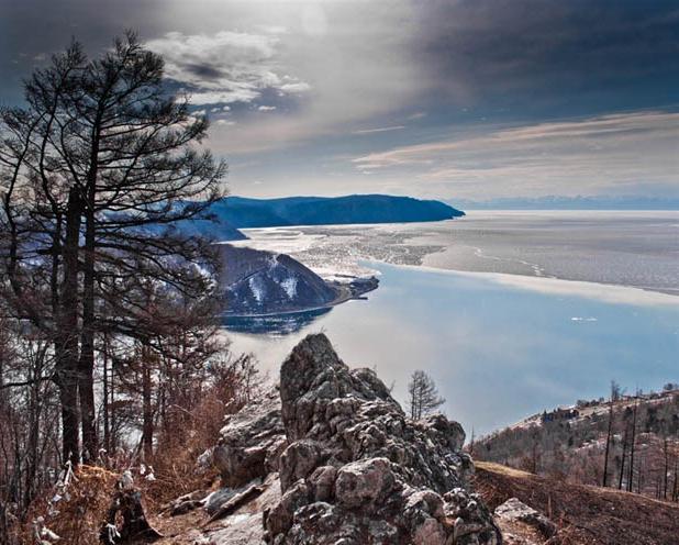
Zabaikalsky State National Park is a true pearl of Buryatia. The unique landscapes of the eastern coast of Lake Baikal, valuable natural complexes, the safety of which was under threat, prompted the Government of the RSFSR in 1986 to issue a decree on the creation of a park in this area, which is under state protection.
Here is a real paradise for animals: more than 44 species of mammals, 50 - vertebrates, 241 species of birds, 3 species of reptiles and the same number of amphibians. Many representatives of the fauna are included in the Red Book of Russia.
The national park is part of a huge complex, a real repository of northern attractions and natural beauty called the Reserved Podlemorie. It includes two more parks - the Frolikhinsky reserve and All three protected areas are part of the Lake Baikal site, which is under the protection of UNESCO.
Features of the park
Territory protected area covers Akademichesky, Sredinny, Svyatonosky and Barguzinsky ridge and in total occupies 269 thousand hectares. 37 thousand hectares is the water area of Lake Baikal, the deepest freshwater lake in the world.
Most of the protected complex is occupied by mountain slopes, abundantly covered with thickets of dwarf birches, dwarf cedar, larch, pine and cedar taiga.

One of the most beautiful places is the Svyatoy Nos Peninsula: the Chivyrkuisky Isthmus connects it with the eastern coast of Lake Baikal. The top of the Akademichesky Ridge, which is the underwater boundary between the northern and southern depressions of the Baikal Basin, is represented by the Small Ushkany Islands and the Big Ushkany Island.
This formation was named the archipelago.
Chivyrkuisky Bay
The Zabaikalsky National Park is famous for the largest freshwater seal rookery on Lake Baikal - the seal. It is endemic to Lake Baikal and the only representative of the pinnipeds order. Most of the seals are found on the Ushkany Islands, where their number sometimes reaches 2500 - 3000 individuals. In autumn, during storms, seals (most often pregnant females) move to Chivyrkuisky Bay. However, this is not a place for their winter quarters: having healed and rested, the seals again go into open water, since the bay is covered with ice.
The bay is famous for its thermal springs, the most famous of which is Serpentine. It owes its name to the population of the common snake inhabiting the Arangatui swamps. The water temperature in the spring sometimes reaches + 50-60 degrees. The mineral springs Nechaevsky and Kulinye bogs are also popular among the guests of the park.
The shores of the Chivyrkuisky Bay are heavily indented, the waters cut into the land for 25 kilometers. This feature led to the emergence of small sandy bays protected from winds up to five meters deep along the entire reservoir. One of the most remarkable is the Ongokon Bay.

Five tourist routes give guests the opportunity to get acquainted with the inhabitants of the protected area, its beauty and breathtaking landscapes. From the highest point of the park - Mount Markovo, located on the Svyatoi Nos peninsula, an amazing panorama of the area opens up.
Islands and park
The nature of Buryatia is diverse and beautiful in any of its manifestations. So, taking a boat trip along the Chivyrkuisky Bay, you can admire the real islands, the steep banks of which have turned into a refuge for numerous dove-gray and winding their nests here.
Climatic features of the park
The park is located in the Middle Baikal eastern climatic region, which is characterized by a continental climate with warm, sometimes dry summers and long cold winter... The influence of Baikal softens the weather conditions in the coastal part of the protected area. average temperature v winter period is -19 degrees Celsius, +14 degrees in summer. The water temperature in the lake does not rise above +14 degrees even on the hottest days.
Water resources of the reserve
Zabaikalsky National Park is rich water resources... Many small rivers flow here, among which the Bolshoi Chivyrkuy, Malaya and Bolshaya Cheremshana stand out. The basins of these rivers are closed, so they carry their waters to Baikal. There are also lakes here: the largest of them are Arangatui and Small Arangatui, located on the Chivyrkuisky isthmus and connected to the bay. Bormashovo Lake is smaller in size and is famous for its mineral waters.

A feature of the park is the presence of karst lakes - there are more than twenty of them.
Flora of the Trans-Baikal National Park
The Trans-Baikal Territory is located in the zone of taiga forests, which directly affects the structure of the vegetation cover of this area. It is due to the vertical zonation of the Trans-Baikal mountain regions. Forests are mainly composed of conifers: Gmelin larch, Siberian fir, pine, cedar and dwarf cedar.
A small area is occupied by deciduous forests, represented mainly by stone and broad-leaved birches and aspens.
The Zabaikalsky National Park is distinguished by an unusual distribution of mountain taiga forests compared to their location in the continental Siberian mountains. So, in the park, the number of cedar-larch and larch trees is relatively small - their area is about 14 thousand hectares, and they are located on madder on river terraces, while in other Siberian forests such trees are represented in the majority.
Endemics and relics
The flora of the protected area is diverse, many plant species are endemic and relict. The most valuable of them settled in the highlands of the Ushkany Islands and Svyatoy Nos.

These include Chosenia, dwarf cedar and dwarf cedar communities, and Tiling borodinia.
Fauna diversity
A real home for sables, wolves, wolverines, bears, foxes, squirrels, elk, brown bears, red-gray voles, hazel grouses, nutcrackers, musk deer, black-capped marmot and many other representatives of the fauna became the Trans-Baikal National Park. Animals feel completely safe here.
Among the representatives of amphibians there are rare species- Siberian and sharp-faced frogs. The six reptile species also found here include the common snake, the snake and the viviparous lizard.
Among the birds, both sedentary and migratory, one can find white and yellow wagtails, brown-headed tit, Muscovy, Dubrovnik, nuthatches, nutcrackers, lapwings, snipe, black gulls, river terns, gray and herring gulls. Sometimes in the park you can see a black stork (the nesting place of which is still a mystery), golden eagle, white-tailed eagle, peregrine falcon and osprey.
One more rare bird, which disappeared from the coast of Lake Baikal and lives in small numbers in the Chivyrkuisky Bay, is the great cormorant.
Many species of birds arrange their nests in swamps, hidden from human eyes and located mostly on the Chivyrkuisky Isthmus. There is also the least transformed ecosystem of the world - the Arangatuy bogs, which are inhabited by moose, wood grouse, muskrat.

The most numerous is the group of waterfowl, represented by the mallard, gogol, pintail, whooper swan, teal-whistle and
There are also owl birds in the park: short-eared and long-eared owls, an eagle owl and a snowy owl are very rare guests, meeting only in winter or in places where a person's foot rarely steps.
National parks of Buryatia, including the Trans-Baikal National Park, are rich in various representatives underwater world... So, in water bodies there are perch, ide, Siberian grayling, dace, burbot, sturgeon, pike, roach and an endemic species - the little golomyanka.
Zabaikalsky National Park: how to get there
Closest to the park locality is the village of Ust-Barguzin.
You can get here by land or water. The best route by land is a private transport service that departs from Irkutsk along the coast of Lake Baikal. From the capital of the Republic of Buryatia - the city of Ulan-Ude - you can get to the park by shuttle taxi or a regular bus.
The distance to the reserve is about 275 km and the road takes about 5-6 hours.
It should be borne in mind that most of the path is on a gravel road. For people who prefer a water route, private flights depart from the port of Baikal, as well as from the villages of Khuzhir, Nizhneangarsk and Listvyanka.
Having visited this park, you will not regret it for a minute, because it is not only the hallmark of Lake Baikal, but also a real oasis of natural wonders, which the Trans-Baikal Territory is so rich in!


